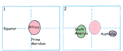
|
In 1995, Geography for Life: The National Geographic Standards stressed the importance of children knowing how to draw a map of the world. It suggested using simple ovals for each continent. We loved the idea and created a lesson for Draw Write Now, Book 7.
The Common Core State Standards recommends that students “use a mix of drawing, dictating and writing to compose explanatory texts.” Drawing a simple world map helps children develop their own mental map, always at the ready as they build an understanding of our world. It’s easy to see how drawing a simple map can add to the ability to use explanatory texts.
|
- The Equator goes through the middle of Africa. The Prime Meridian is on the edge of the continent.
- Australia is close to the Equator and the edge of the paper. It is much smaller than Africa. South America is closer to Africa than Australia is to Africa. (The mouth of the Amazon River is at the Equator.)
- Antarctica is at the South Pole, the base of the Prime Meridian.
- Asia is close to the top and right edge of the paper. It touches the Equator and connects to Africa.
- Europe is directly above Africa and is connected to Asia. The Prime Meridian goes through England.
- North America is close to the top edge of the paper, the Equator and the left edge of the paper.

|
|
|
|
|
Fold a sheet of 8-1/2 x 11” paper into quarters. Reopen the paper, and position it horizontally on the desk. The horizontal fold line is the Equator, and the vertical fold line is the Prime Meridian, with the North Pole at the top of the line and the South Pole at the bottom.
|
|
Refer to a globe or a flat map while introducing and drawing each continent. Use the Equator, Prime Meridian and the edges of the paper as guides.
- North Pole and South Pole—the northern and southern points of Earth’s axis of rotation.
- Equator—the horizontal imaginary line that circles the globe, halfway between the two poles.
- Prime Meridian—the vertical imaginary line running from the North Pole to the South Pole through Greenwich, England.
|
|
Color each continent using a crayon, shifting the edges or enlarging the oval to adjust the scale and proportion of the continent. (The instructions show the continents outlined, but it’s best to omit outlining or leave outlining to the end.)
|
|
Encourage the children to write all the names horizontally and to keep the size consistent.
|
|
Include the geographic lines and points: Equator, Prime Meridian, N, S, E, W.
|
|
|
Reader Comments